The printable version is no longer supported and may have rendering errors. Please update your browser bookmarks and please use the default browser print function instead.
Neighborhood of Maastricht in Netherlands, Limburg
Binnenstad (Dutch pronunciation:[ˈbɪnə(n)ˌstɑt]; Limburgish: Binnestad[ˈbɪnəˌstɑt]; English: Inner city) is a neighbourhood in Maastricht, Netherlands. Until 2007, it was officially named City. As its name suggests, it is the most centrally located area of Maastricht.
Notable features
Dinghuis, a Medieval courthouse
The Dominicanenkerk (Dominican Church), a former church now housing a book shop


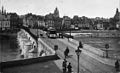 Historic picture of the Binnenstad seen from the opposite bank of the Maas
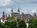 Panorama, with three churches (Onze-Lieve-Vrouwekerk, Sint-Janskerk and Sint-Servaasbasiliek)
 Pubs on the Vrijthof square
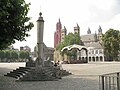 View of the Vrijthof square, with the Maastrichtian perron in the foreground
 Shop in the Stokstraatkwartier
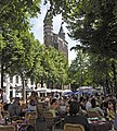 The Onze-Lieve-Vrouweplein
 Dinghuis and the Kleine Staat street, as it looked in 1957

.jpg)


