Taskan (village)
Taskan
Таскан | |
|---|---|
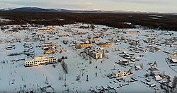
 View of Taskan in 2019 | |
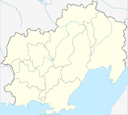
| Coordinates: 62°59′11″N 150°19′43″E / 62.98639°N 150.32861°E | |
| Country | Russia |
| Federal subject | Magadan Oblast |
| District | Yagodninsky District |
| Population (2021) | |
| • Total | 0 |
| Time zone | UTC+11:00 |
Taskan (Russian: Таскан) was a rural locality in Yagodninsky District, Magadan Oblast, Russian Far East.
There is a road leading to Yagodnoye to the southwest of Taskan and another to Elgen to the southeast.[1]
Geography[edit]
This abandoned settlement is located in the Upper Kolyma Highlands by the confluence of the Mylga and the Taskan, a left tributary of the Kolyma that flows from the Chersky Range.[2]
History[edit]
Taskan was established in the 1930s. In the 1940s, there was a food processing factory which employed mostly prisoners. In the 1960s, the first two-story wooden buildings were built, as the economy began to develop. By 1993, the population had risen to about 850 inhabitants and there was a state farm that specialized in animal husbandry and the growing of vegetables. The population fell rapidly after the collapse of the USSR and only a residual population remained. According to the 2010 census only 30 people lived in Taskan.[3] Finally the settlement was abolished in 2019.[4]
Yevgenia Ginzburg (1904 - 1977), a Soviet author, served a term in Taskan as a nurse during her imprisonment in the 1940s under Stalin's regime.


