
Dienville: Difference between revisions
Content deleted Content added
No edit summary |
added Use dmy dates template |
||
| (42 intermediate revisions by 26 users not shown) | |||
| Line 1: | Line 1: | ||
{{ |
{{Use dmy dates|date=August 2023}} |
||
{{short description|Commune in Grand Est, France}} |
|||
{{Infobox French commune |
{{Infobox French commune |
||
|name |
|name = Dienville |
||
|commune status = [[Communes of France|Commune]] |
|||
|region = Champagne-Ardenne |
|||
| |
|image = Dienville, l'église et le pont sur l'Aube.JPG |
||
|caption = The church and the bridge over the Aube river in Dienville |
|||
|arrondissement = Bar-sur-Aube |
|||
|image coat of arms = Blason ville fr Dienville 10.svg |
|||
|canton = Brienne-le-Château |
|||
| |
|arrondissement = Bar-sur-Aube |
||
| |
|canton = Brienne-le-Château |
||
| |
|INSEE = 10123 |
||
| |
|postal code = 10500 |
||
|mayor = Claude Large<ref>{{cite web|title=Répertoire national des élus: les maires|url=https://www.data.gouv.fr/fr/datasets/r/2876a346-d50c-4911-934e-19ee07b0e503|publisher=data.gouv.fr, Plateforme ouverte des données publiques françaises|date=13 September 2022|language=fr}}</ref> |
|||
| ⚫ | |||
| |
|term = 2020–2026 |
||
| ⚫ | |||
|latitude = 48.3513888889 |
|||
|coordinates = {{coord|48.3514|4.5344|format=dms|display=inline,title}} |
|||
|elevation m = 128 |
|||
|elevation |
|elevation m = 128 |
||
|elevation |
|elevation min m = 120 |
||
| |
|elevation max m = 186 |
||
| |
|area km2 = 20.34 |
||
|population |
|population = {{France metadata Wikidata|population_total}} |
||
|population date = {{France metadata Wikidata|population_as_of}} |
|||
|population footnotes = {{France metadata Wikidata|population_footnotes}} |
|||
}} |
}} |
||
'''Dienville''' is a [[Communes of France|commune]] in the [[Aube]] [[Departments of France|department]] in north-central [[France]]. |
'''Dienville''' ({{IPA-fr|djɛ̃vil}}) is a [[Communes of France|commune]] in the [[Aube]] [[Departments of France|department]] in north-central [[France]]. |
||
==History== |
|||
The village of Dienville is mentioned in 864 under the name Dienvilla. There remains an [[Ancient Rome|Ancient Roman]] road, a vestige of that era. |
|||
On 1 February 1814 the village was fought over during the [[Battle of La Rothière|Battle of La Rothiere]]. |
|||
==Population== |
|||
Dienville was the home of Abbé Courtalon Delestre (1735-1786), a historian and poet, and [[:fr:Jean-Baptiste Courtalon]] (1740-1797), Cleric of the Chapel for [[Louis XV]] and [[Chaplain]] of [[Louis XVI]]. |
|||
{{Historical populations |
|||
|align=left |
|||
|1962|844 |
|||
|1968|844 |
|||
|1975|812 |
|||
|1982|781 |
|||
|1990|796 |
|||
|1999|747 |
|||
|2008|809 |
|||
}} |
|||
{{clear left}} |
|||
<gallery heights="150" widths="150"> |
|||
Dienville_Mairie_R02.jpg|Town hall |
|||
Dienville_Eglise_R03.jpg|Saint Quentin church |
|||
Dienville_Halle_R01.jpg|Market hall |
|||
Dienville_Monument_aux_Morts_R01.jpg|War memorial |
|||
</gallery> |
|||
==See also== |
==See also== |
||
*[[Communes of the Aube department]] |
*[[Communes of the Aube department]] |
||
*[[Parc naturel régional de la Forêt d'Orient]] |
|||
==References== |
==References== |
||
*[http://www.insee.fr/en/home/home_page.asp INSEE] |
|||
{{reflist}} |
{{reflist}} |
||
{{commons category}} |
|||
{{Aube communes}} |
{{Aube communes}} |
||
{{authority control}} |
|||
[[Category:Communes of Aube]] |
[[Category:Communes of Aube]] |
||
| Line 37: | Line 69: | ||
{{Aube-geo-stub}} |
{{Aube-geo-stub}} |
||
[[ceb:Dienville]] |
|||
[[es:Dienville]] |
|||
[[fr:Dienville]] |
|||
[[it:Dienville]] |
|||
[[nl:Dienville]] |
|||
[[pl:Dienville]] |
|||
[[pt:Dienville]] |
|||
[[simple:Dienville]] |
|||
[[sr:Дјенвил]] |
|||
[[uk:Дьянвіль]] |
|||
[[vi:Dienville]] |
|||
[[vo:Dienville]] |
|||
[[war:Dienville]] |
|||
Latest revision as of 04:29, 1 August 2023
Dienville | |
|---|---|
 The church and the bridge over the Aube river in Dienville | |
 Coat of arms | |
Location of Dienville  | |
 Dienville  Dienville | |
| Coordinates: 48°21′05″N 4°32′04″E / 48.3514°N 4.5344°E | |
| Country | France |
| Region | Grand Est |
| Department | Aube |
| Arrondissement | Bar-sur-Aube |
| Canton | Brienne-le-Château |
| Government | |
| • Mayor (2020–2026) | Claude Large[1] |
| Area 1 | 20.34 km2 (7.85 sq mi) |
| Population (2021)[2] | 834 |
| • Density | 41/km2 (110/sq mi) |
| Time zone | UTC+01:00 (CET) |
| • Summer (DST) | UTC+02:00 (CEST) |
| INSEE/Postal code | 10123 /10500 |
| Elevation | 120–186 m (394–610 ft) (avg. 128 m or 420 ft) |
| 1 French Land Register data, which excludes lakes, ponds, glaciers > 1 km2 (0.386 sq mi or 247 acres) and river estuaries. | |
Dienville (French pronunciation: [djɛ̃vil]) is a commune in the Aube department in north-central France.
History[edit]
The village of Dienville is mentioned in 864 under the name Dienvilla. There remains an Ancient Roman road, a vestige of that era.
On 1 February 1814 the village was fought over during the Battle of La Rothiere.
Population[edit]
Dienville was the home of Abbé Courtalon Delestre (1735-1786), a historian and poet, and fr:Jean-Baptiste Courtalon (1740-1797), Cleric of the Chapel for Louis XV and Chaplain of Louis XVI.
| Year | Pop. | ±% |
|---|---|---|
| 1962 | 844 | — |
| 1968 | 844 | +0.0% |
| 1975 | 812 | −3.8% |
| 1982 | 781 | −3.8% |
| 1990 | 796 | +1.9% |
| 1999 | 747 | −6.2% |
| 2008 | 809 | +8.3% |
-
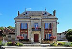 Town hall
 -
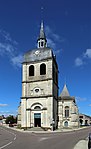 Saint Quentin church
 -
 Market hall
 -
 War memorial


See also[edit]
References[edit]
- ^ "Répertoire national des élus: les maires" (in French). data.gouv.fr, Plateforme ouverte des données publiques françaises. 13 September 2022.
- ^ "Populations légales 2021". The National Institute of Statistics and Economic Studies. 28 December 2023.
Wikimedia Commons has media related to Dienville.
| International | |
|---|---|
| National | |
This Aube geographical article is a stub. You can help Wikipedia by expanding it. |